5 Best Free & Paid Property Mapping Software Apps for Residential & Commercial Real Estate (2025 Reviews)
Real Estate Bees’ editorial team asked a number of industry-leading real estate investors and property development companies to share their first-hand experience with their must-have apps for mapping property lines of residential and commercial real estate to help our readers make a more educated purchase decision when researching available solutions.
Based on the received responses, we narrowed down all the tools to the following 5 best property mapping apps for residential and commercial real estate:
- Land id – Most customizable property mapping tool
- eSpatial – Most intuitive real estate mapping app
- Maptive – Best feature-rich real estate map software tool
- REBLIE – Best commercial property line mapping app
- Mapme – Best real-time property mapping software

With the help of the experts, we identified the best free and paid real estate mapping software tools and evaluated them based on critical factors that are important for real estate investors and developers. Visiting retailers of the listed products by clicking links within our content may earn us commissions from your purchases, but we never receive any compensation for the inclusion of products and/or services in our consumer guides. Read our editorial guidelines to learn more about our review and rating process.
Land id

Whether you’re flipping houses or managing farmland, Land id gives you a simple way to assess and showcase any property.
It is one of those real estate mapping software tools that lets you get detailed land data and craft interactive maps.
Land id brings your real estate projects to life — from your computer or smartphone.
This real estate map software tool helps you get down to the details with tools like deed plotting, custom map creation, and precise distance measurements.
Land id makes setting up a geographical database easy. It also integrates with GIS technologies. This allows you to look at and interpret complex data easily.
Features
Interactive Maps
With Land id, you can create vibrant interactive maps with photos, videos, and icons. The combination of these media formats gives you a virtual tour that highlights every inch of your property.

Create and Share Custom Map
Land id allows you to draw up boundaries, measure spaces with precision, and mark the must-sees so anyone can grasp the map layout at a glance.

Basemaps and Overlays
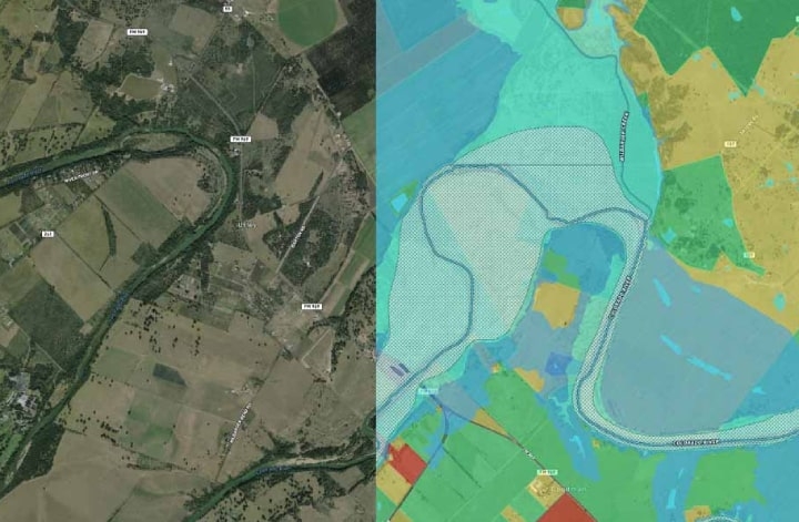
Land id gives you a variety of basemaps — satellite views and topographical maps spiced up with over 40 overlays, including zoning information, property lines, etc.
It offers better insights into every crevice of your land.

Georeference Images and Deed Plotting
Land id allows you to overlay your surveys on aerial maps for a clearer context. This lets you perfect your plot plans with an array of georeferenced images and GIS overlays that ensure accuracy.

Plans and Pricing
Whether you’re just getting started or you’re a seasoned real estate investor or property developer, Land id offers multiple plans to fit everyone’s needs — and you can start with a 7-day free trial.
With its 7-day free trial which is uncommon for sophisticated software for real estate, Land id can almost pass off as one of the best free real estate mapping tools.
Discover: At only $14.99 a month or an annual price of $79.99 (56% savings), this plan gives you detailed land identity insights, 3D mapping, and all the essential information you need — from ownership details and boundaries to tax details.
Pro: For $49.99 monthly or $399.99 yearly (33% discount), this plan builds on the Discover plan, giving users advanced custom map making tools (3 custom maps per month), georeferencing, deed plotting, personalized feature highlighting, and multimedia additions, including 360 panoramas and 40+ unique markers.
Pro Unlimited: At $79.99 a month or $799.99 a year, this plan unlocks everything in Pro, plus unlimited custom map creation, multi-user access, and centralized billing.

Pros and Cons
Pros
- Customization options. Land id lets you customize your maps your own way. You can add your own icons, photos, and even panoramic views to capture every detail just as you want it.
- GIS layers and data integrations. Land id simplifies your data with interactive maps layered with all the GIS information you need for a clearer land analysis.
- Offline and online functionality. Land id allows you to take or work with your maps anywhere — on or offline. You can share them easily with colleagues through email or text, or even on your real estate investor website.
Cons
- Difficult to use. Land id’s customization and layers are good but can be difficult to use if you’re new to GIS technology.
- Limited access to the full features. You can use your maps offline, but Land id works better online. If you have bad internet, you might be unable to access all its cool features.
- Mobile app limitations. The mobile app doesn’t match the desktop version. Things like tweaking data details or creating custom reports only work on desktop.
Integrations
- AscendixRE
- AgWare UAAR
- Google Maps
- QGIS
- Microsoft Excel
eSpatial

eSpatial shows you in-depth information about real estate properties, neighborhoods, and amenities.
This property line mapping app gives you the scoop on market trends that matter — from sales to demographic shifts.
eSpatial lets you filter homes by location, price, size, or amenities. This makes it easy to pinpoint the perfect homes for real estate agents’ clients.
Its unique proximity analysis feature adds local schools, parks, and hospitals to your maps.
This improves your ability to evaluate a property’s neighborhood context as a part of real estate due diligence.
Features
Visual Representations and Spatial Relationships
As real estate investment analysis software, eSpatial shows you how properties relate to each other and the local hotspots.
It paints a vivid picture of neighborhoods, pinpointing everything from schools to shopping malls.

Market Analysis
eSpatial makes it easy to create reports on market trends, property values, and demographic shifts.
Being a great addition to your real estate comps software, it allows you to overlay different data points to give sellers a complete overview of the market.

Property Search
eSpatial filters homes by your chosen criteria, whether by price, size, or must-have amenities. It lets you find ideal listings quickly and shows clients exactly what they are looking for.

Client Communication and Customization
eSpatial allows you to customize maps to do more than just show locations. The software gives your clients a personalized tour of any neighborhood, highlighting what matters most to them.

Plans and Pricing
eSpatial offers 4 plans: Map Maker, Team Map Maker, Territory Map Maker, and Enterprise Map Maker Suite.
Map Maker: At $1,495 a year, this plan includes everything from advanced maps (heat maps, color-coded maps, and pin maps) to secure sharing, route planning, and drive-time analysis. This plan is for just one user.
Team Map Maker: Priced at $4,995 yearly, this plan scales the base plan up to support 10 users. You get all the features of the Map Maker plan, plus additional features to support teamwork.
Territory Map Maker: At $7,995 annually, it offers everything for detailed sales territory management (create, align, and manage territories), plus everything in the Map Maker plan. It is designed for two users.
Enterprise Map Maker Suite: This plan offers everything in Territory Map Maker for up to five users. It also includes advanced features like scenario planning, territory hierarchies, workload balancing, territory optimization, and enterprise support. It uses custom pricing.

Pros and Cons
Pros
- Ease of use and intuitive interface. Even if you’re not a tech whiz, you’ll find eSpatial’s interface easy to use. Making maps on the platform is quick and easy. There is also a mobile real estate mapping app for creating maps from anywhere.
- Powerful visualization tool. eSpatial allows you to create stunning, detailed maps that make property stats shine.
- Route and territory optimization. eSpatial doesn’t just help you plan your trips; it also fine-tunes territory assignments for real estate brokerages.
Cons
- Lack of custom drawing territory. You can only draw the territory you need if it matches eSpatial’s pre-set options (such as the usual city or zip code lines).
- Performance issues with large datasets. eSpatial lags when handling large datasets, which can affect your productivity.
Integrations
- Salesforce
- Zoho Analytics
- iSMART
- Excel
Maptive

Maptive transforms your data into simple maps in no time. As one of the best real estate mapping software tools, Maptive gives you powerful mapping features.
You can easily discover the quickest paths, generate stunning heat maps, or look at demographic trends with the ability to plot up to 100,000 locations.
Maptive’s heat map generator paints your data story in vibrant colors, showing exactly where sales are booming.
Features
Territory and Demographic Tools
Maptive lets you divide your map into key submarkets to give clients a clear view of demographics like housing trends, age groups, education levels, and income.
The software makes it easy to pinpoint the perfect locations for your clients.

Pin Maps and Property Visualization
Maptive lets you upload and display your property listings on an interactive map. The software helps you manage and showcase properties effortlessly.

Filter Tool
Maptive uses filters to remove listings that don’t match your clients’ specific needs. From square footage to zoning, the software allows you to present only the properties that matter.

Drive Time Polygon and Radius Tool
Maptive allows you to visualize how far you can travel within a set time and helps you find the quickest path. This saves time and makes every property tour smooth.
Plans and Pricing
Maptive offers 4 pricing plans for your projects: 45 Day Pass, Pro, Team, and Enterprise.
All plans offer Google Maps integration, unlimited access to their toolkit, and stellar support via phone, chat, or email.
45 Day Pass: For just $250, you unlock 45 days of premium access. You’ll get everything you need for one user, including access to all map tools like the radius tool and geographic boundary tool, advanced filtering, route and direction optimization, and storage for up to 250,000 locations and 150,000 locations geocoded.
Pro: At $1,250 a year (or $110 monthly) for one user and $750 yearly for additional user licenses, this plan gives you everything in the 45 Day Pass, plus API access and storage for up to 600,000 locations with 400,000 locations geocoded.
Team: Priced at $2,500 annually (or $220 every month), this plan supports your team of 5 with storage for 15 million locations and 1 million locations geocoded. Extra teammates cost just $500 each. It includes all Maptive features, plus map collaboration tools and dedicated support.
Enterprise: Tailored for the big leagues, the Enterprise plan offers a custom-fit solution for those craving high volume data capacity, 10+ licenses, advanced support, and more customization. You can get in touch with Maptive customer care for a quote.

Pros and Cons
Pros
- User-friendly interface and tools. Maptive’s interface is simple to use. Many users find it refreshingly straightforward and packed with features that are tailor-made for real estate professionals.
- High-speed geocoding and customization. Not only does Maptive load data in a snap, but its customization tools, like the radius feature, also make your maps look better.
- Robust support and training. You can always reach customer support at Maptive. They also offer comprehensive training for new users.
Cons
- Cost. Maptive isn’t the most budget-friendly option, especially for smaller real estate teams or those who only work with real estate mapping every now and then.
- Integration issues. Sometimes, getting Maptive to integrate with tools like Google Sheets or Excel is difficult. You might need to tweak headings or some details here and there to ensure correct integration.
Integrations
- Google Maps
- Microsoft Excel
REBLIE

Designed with real estate professionals in mind, REBLIE simplifies map creation. This app for mapping property lines combines all the crucial data you need in one package.
Plus, it gives you the power of GIS (Geographic Information System) and AGS (Applied Geographic Solutions) technologies for that extra edge you need.
REBLIE allows you to create sleek branded maps instantly. Users can add GIS insights, traffic flows, local landmarks, and more to their maps.
REBLIE’s tools are built for the commercial real estate world, perfect for agents, investors, and developers alike.
Features
Logo Database
With REBLIE, you can instantly pull logos from nearby businesses right onto your map. This removes the need for you to search manually and also keeps your map looking professional.

Property Search
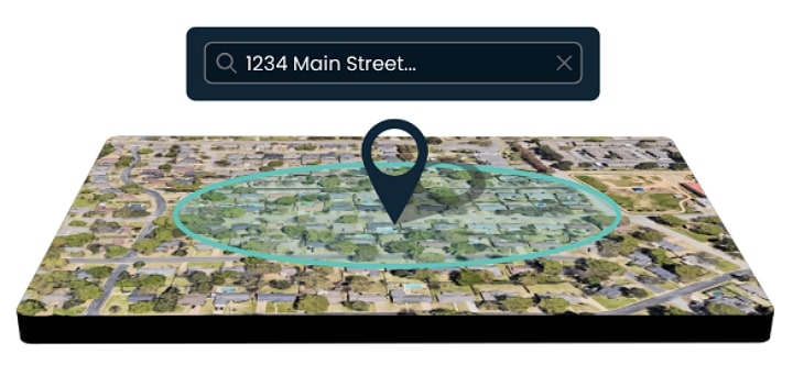
With REBLIE, you can enter an address and get a birds-eye view of any property.
This real estate map software allows you to rotate your view north, south, east, or west, and zoom in to catch every little detail that matters to you and your project.

Branded Map Creation
REBLIE allows you to create sleek custom maps in a short time. Whether for a client presentation or a big project, it lets you look like a pro no matter your experience level.

Plans and Pricing
REBLIE has two plans: REBLIE Essentials and REBLIE Pro. Both plans offer nationwide mapping, unlimited map creation, and demographic insights.
For both plans, interested users have to book a demo to get customized pricing information.
REBLIE Essentials: This plan includes features like merchant SVG logos, 24/7 support, and drive-time overlays for when “nearby” needs to be precisely defined.
You can also export your maps just the way you want, customize templates, create demographic reports, and upload your images.
REBLIE Pro: This plan adds environmental reports, retail gap analysis for retail properties, crime risk, and consumer expenditure to all the features of the Essentials plan.

Pros and Cons
Pros
- Streamlined workflow and collaboration. With its easy-to-use features, REBLIE lets your team edit together in real time and access map history quickly.
- Time efficiency. REBLIE allows you to create detailed maps and scoop up all the crucial information on multiple properties at once. This removes the need for endless searches.
- Branded maps. REBLIE offers more customization tools for map creation. Users can add logos, radius ring, or drive time overlays, and custom images.
Cons
- No pricing information. REBLIE keeps its pricing undisclosed. You’ll need to contact them directly to get the cost of their two plans.
- Dependence on AGS data. The power of REBLIE’s insightful maps hinges entirely on the data quality from Applied Geographic Solutions (AGS), unlike other real estate mapping software tools.
- Insufficient information about the software online. There are no comprehensive details or user reviews on REBLIE. This might hinder those seeking more information before committing.
Integrations
- Applied Geographic Solutions
- SafeGraph
Mapme

Mapme makes creating interactive maps easy for everyone. It is a property mapping software tool that allows you to organize properties by price, size, or amenities, helping your clients find what they need at a glance.
Mapme helps you create your maps with custom styles, colors, and layouts. You can also add photos, videos, and even 3D tours.
As some of the best mapping software for commercial real estate, Mapme is designed with tracking tools to reveal which sites get the most activity. This can help you refine your engagement strategies.
Features
Incorporating Media Sources
Mapme lets you add photos, videos, audio, PDFs, Matterport 3D tours, and more.
By integrating directly with real estate virtual tour software like Matterport, Mapme gives your clients a truly engaging property showcase experience.

Categories and Filters
Mapme allows you to quickly sort properties by using intuitive categories and dynamic filters.
Whether it’s by price, size, or amenities, Mapme allows you to display only what’s most relevant to your viewers.

Data Import and Update
Mapme allows you to import data from Excel or Google Sheets, or update existing locations in bulk.
Thanks to its easy-to-use map editor and seamless Google Sheets integration, you can create interactive maps in minutes.

Plans and Pricing
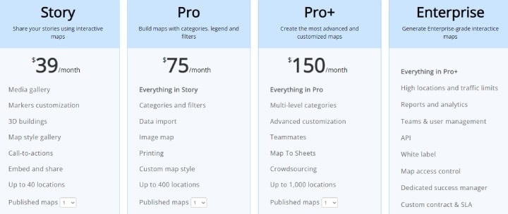
Mapme offers 4 pricing plans: Story, Pro, Pro+, and Enterprise.
Story: For just $288 a year (39% off the monthly plan) or $39 a month, you get features like multimedia galleries, stylish markers, and 3D buildings.
This plan also allows you to share your maps, and spark action with a call to action. It allows you to add up to 40 locations.
Pro: At $588 a year, saving 35% yearly or $75 a month, you get everything in Story, plus features like sort by categories, Excel and Google Sheets data import, custom map styles, and printing options for your map. It covers up to 400 locations.
Pro+: For $1,188 per year or $150 monthly, you can enjoy Pro perks, plus features like multi-level categories, advanced designs with CSS/HTML, team collaboration tools, syncing from your map to Google Sheets, and crowdsourcing, all for up to 1,000 locations.
Enterprise: For full-scale operations, this plan goes beyond the extras, giving you everything in Pro+, along with 20,000+ locations.
It is tailored for businesses with high location and map traffic requirements, and packed with analytics, team management tools, API access, white-labeling, and map access controls, complete with a dedicated success manager in your corner.

Pros and Cons
Pros
- Highly customizable maps. Mapme lets you spice up your maps with photos, videos, documents, and even 3D and 360 tours.
- Matterport integration. Mapme integrates right with the platforms you use daily, making it easy to share maps with clients or tenants. Its integration with Matterport makes it one of the best commercial real estate mapping software tools.
- Offline and real-time capabilities. Mapme lets you work offline without a hitch and you also get real-time updates to keep you in the loop.
Cons
- Lag and performance issues. Mapme’s web interface sometimes loads slowly. The platform currently has no mobile app.
- Location accuracy. Mapme sometimes gets its cafes, locations, and properties mixed up, which could lead your clients to the wrong places.
- Multiple stops and routing. Planning a multi-stop tour of properties can be difficult. You have to input each stop separately, which may be stressful and time-wasting.
Integrations
- Google Sheets
- Google Forms
- Google Docs
- Google Maps
- Matterport
- YouTube
- Vimeo
- Microsoft Excel
- WordPress
Here at Real Estate Bees, we take the content competency, validity and accuracy very seriously. Each piece of content published in our knowledge base containing the "Expertise Verified" trust badge indicates its author's qualified industry expertise and first-hand experience with a given subject matter.
Content authors possessing the "Expertise Verified" trust badge are all active industry experts in their respective field whose professional expertise, qualification and credentials have been thoroughly verified by our editorial team as part of our Expert Contributor Program's onboarding process.
Such fierce editorial standards ensure our content is of the highest possible quality in the industry making it highly competent, credible and trustworthy for you - the reader.
